Stories of the Estuary: The TMDL/Dissolved Oxygen ConnectionBy Harry Branch
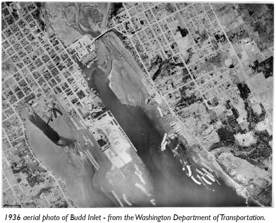
How things were Historically, Budd Inlet was a vast estuary for the combined Deschutes River and four major streams, Moxlie, Percival, Schneider and Ellis Creeks. The influence of these streams should not be overlooked because they impact the structure of a wider marine area than the river, Budd Inlet. In aerial photos of Budd Inlet taken in 1936, it is evident that much of the historic estuary had already been filled to create downtown Olympia. One can imagine how the estuary from Priest Point Park south to the corner of Plum and Union, back and forth through all of downtown Olympia and around the corner to the falls, then all the way up the West Side, all used to be tide flats. The adjoining near shore was a combination of salt marsh and overhanging vegetation. As of 1936, even though Moxlie Creek had already been run through a pipe, the rest of the streams and the river were intact. Budd Inlet at that time was a rich, highly productive ecosystem teeming with eelgrass, seaweed, herring, smelt, shiner perch, sculpins, flat fish and diving ducks by the thousands. These species all relied on good water quality with enough dissolved oxygen and a healthy food web, beginning at the point of primary production. We can only imagine what Budd Inlet was like a hundred years ago. An estuary as vast as the one we can visualize in the 1936 photo must have been astounding in its bounty. How an estuary works, the TMDL/dissolved oxygen link TMDL is an acronym for Total Maximum Daily Load of nutrients in a stream or river. Nutrients entering marine waters are consumed by marine plants called algae, especially free swimming algae called phytoplankton. When too many nutrients enter some systems, phytoplankton overproduce, die and rot, creating first a spike then a drop in dissolved oxygen and the water becomes anoxic. However, given the right conditions, the marine environment has a tremendous capacity to digest nutrients without becoming anoxic. Ironically, when working properly, phytoplankton create not only dissolved oxygen but about three-fourths of the earth's atmospheric oxygen, and also serve as the primary producers, the base of the food web. Virtually all life in the sea depends on phytoplankton. Before we rush to condemn nutrients we should remember that nutrients and sunlight are the building blocks of life without which phytoplankton can't survive. We should also remember that hundreds of years ago when thousands of salmon died and rotted in area streams these streams were loaded with nutrients. Almost any plant or animal without some control on its abundance will overproduce. The natural control on phytoplankton abundance is the grazers or herbivores, tiny crustaceans called copepods. These creatures represent a larger biomass than any other animal. After consuming phytoplankton they are in turn consumed by everything from herring to whales. Copepods settling to the bottom are the world's largest carbon sink, remediating about one-third of all human contributions to atmospheric carbon. In a healthy estuarine environment, there's a mix of phytoplankton and herbivores. A natural estuary is characterized by a long shallow run out. The tide flowing in and out through a vast network of tide flats and channels twice each day brings herbivores well up into the system where they can control the production of phytoplankton. The process has evolved over millions of years to occur in shallow water in the presence of sunlight and atmospheric oxygen. How things have changed Structure is the most basic oceanographic parameter and estuaries have very particular structures. Today the Deschutes River is dammed, with the heart of the estuary dredged. Plans are in place to increase the dredged area by half a million cubic yards. Moxlie Creek runs through a pipe all the way from Plum and Union to the head of East Bay. Upon entering East Bay it flows for a short distance over tide flats but then encounters dredged channels. Percival Creek flows into Capitol Lake and the estuary of Schneider Creek flows through a 450-foot long culvert. Only Ellis Creek running through Priest Point Park is more or less intact. We've filled some places and dredged others, now beach and salt marsh are replaced by rock and concrete. The role of the Port of Olympia is impossible to overlook. The complete alteration of the structure of Budd Inlet has without doubt impacted other basic parameters. Dissolved oxygen is critically low. Where phytoplankton and copepods used to grow, bacteria now grow. As recently as fifteen years ago on a winter sail from Olympia to Boston Harbor a person could see perhaps 100 surf scoters, 20 grebes, 20 white winged scoters, numerous harlequins and mergansers, and a couple of rhinoceros auklets. These diving ducks in combination are the most visible apex predator, the best indicator of the health of the ecosystem. Today a person is fortunate to see any diving ducks. The latest report from the Puget Sound Partnership leaves little doubt--we're presiding over the death of an ecosystem. Where to go from here Almost every foot of the Port peninsula could include some kind of restoration. Docks could be built away from the bank and the bank behind and between docks knocked back and planted with salt marsh plants. Docks could be built in ways that allow light to pass through. Buildings could be designed and built in ways that mimic natural features. The current model of lawn and landscaping only provides habitat for resident Canada Geese. Construction in historic tide flats such as NorthPoint or the East Bay development sites would not even be considered in New York, New Jersey and California because damage to the Hudson River and San Francisco Bay has reached a critical point. The value of estuaries is clearly understood when we lose them. The worldwide loss of estuaries is a growing concern, not just for local impacts but global oceanographic and atmospheric impacts. At the federal level, the Ocean Policy Task Force is finalizing Coastal and Marine Spatial Planning. Structure, how space is defined, is the key to ecosystem recovery. Under 'ecosystem-based management,' all physical, chemical and biological parameters are considered and decisions are based on the reality of a given location rather than abstract rules. For example, a prohibition on building anywhere within 200 feet of the water is arbitrary. That distance in and of itself doesn't guarantee protection or promote any improvement. There are even ways to build out over the water if enhancements are included in the design. On a state level, acquiring an ecosystem-based management model will require a legislative effort to revise existing state laws; this will take some time. In the interim, the city could decide that any construction along the waterfront would have to enhance or improve ecological function by incorporating restorations and enhancements into their design. As seen in the 1936 aerial photo, the Marine Terminal, Percival Landing and the Yacht Club and precursors to West Bay Marina appear in their current locations, prior to the existence of the dam. These features were no doubt constructed in areas of natural estuarine scouring and would require only minimal maintenance dredging after removal of the dam. Roads and other structures should be built in ways that don't impede natural processes. We don't need to destroy an estuary to get across it. Harry Branch has a Masters Degree in Environmental Studies with a focus on marine reserves as a tool in fishery management. He has also served as a captain operating research vessels for agencies like NOAA. He's worked on sea otter catch and release efforts, bioassays, bird counts and other live science.
Back to Home page. |

 Perhaps it's unreasonable to think we can ever return to a completely natural system, but natural systems are the best model. They're the most productive. They maintain themselves at no cost to us.